Today, I'll tell you about time itself.
Timing is everything, they say, but timekeeping, too, is just as important. In fact, timekeeping turned out to be the solution to the greatest technical problem in history.
All the world's a stage.
The American colonies were caught in the crossfire of politics abroad. England was, like most European countries at the time, at war with all the other European countries. Sometimes cold, sometimes hot, all of Europe was a powder keg. There were some attempts to build unity, usually through marriage. But, as often as not, that backfired. King George II of England, for example, was not even English. He was German. And he didn't speak English very well. And yet, as 'international' and 'diverse' as all this sounds, and whatever power the bond of marriage might have lent a union, power ultimately knows no loyalties, and England, and King George, were pretty much still at war with everyone else, in an effort to stay in power. And this was not completely without justification, as all the other kings were pretty much up to the same thing, too. So it was just self-defense and survival of the fittest.
So, we have a German king of England, and international strife as bad as ever. To make matters worse, France was challenging England's role in the new world, and England was responding not only by fighting the French here, and back home, but by tightening up on the colonies, as well. After all, there were plenty of suspicious foreigners here, and not just Frenchmen, but, quite ironically, Germans, too. And lots of them. (In fact, this country is, still today, predominantly German by descent.) And those Germans were none too happy about the German/English king cracking down on them. As a result, George II wasn't very popular anywhere on either side of the Atlantic.
Then he died.
A soap-opera writer couldn't make this stuff up.
Talk about timing. This put England in the position of changing hands just as things were seriously heating up in the Americas. Talk about changing horses in the middle of the stream! (Look up the Roman siege of Jerusalem.) Remember all those offended Germans? George II's grandson, George III (I know, right? Figure that one out.), inherited the crown, and the British really liked him because he was, in their view, well, actually British. Not only did he grow up in England, but he spoke the language fluently, even natively, and was a bit of a nationalist to boot, something the British were in a mood for at the time. There was one little problem, though.

George III was sick. And not just a little. A lot. And not just in body, but in mind. As in 'sicko'. Wacko. Total loon. In fact, toward the end of his life, he was effectively committed to an asylum while his own son went about trying to wrest control of whatever was left of the kingdom from him. The Brits don't talk about this much anymore, and, when they do, it's all about the end of George III's reign, when practically everybody had to face up to, and deal with the fact that, while legitimately ill, as a result of that illness, their king was nonetheless flat-out bat-guano bonkers. The unspoken truth is that the man was coming unraveled all along. Toward the end of his life, it just became undeniable, and even unconcealable. But, even as a child, there were those close enough to him to know him well who were genuinely worried about what kind of king he'd become.
And he didn't let them down.
George III was popular with the people because they only got to hear the speeches, watch the parades, and otherwise admire from afar. But those who knew better were literally scrambling to save England from its own king, which is why some argue that no king really ever has as much power as they're allowed to think they have. Even George's own Parliament was trying to get him to abandon the colonies before he ruined England over them. (Sound familiar?) You never hear about that part, though, do you?
You see, the colonies, while definitely a status symbol, were expensive, so expensive that the British were determined to either wring every bit of profit from them that could be managed, or cut their losses and run. But, with the French lurking about, George wasn't about to let anyone else benefit from what his kingdom had spent so much time and money developing, Parliament (and the budget) be damned. And this, of course, put him at odds with Parliament.
But why were they so expensive?
Ultimately, all the reasons come down to this: Time and distance.
Why has mankind sailed the seas?
The fact is that, as long as there have been seas (and there weren't always) (but more on that some other day), there has been a relatively inexpensive alternative to land travel. You see, whatever complications sea travel imposes, land travel additionally imposes lots of humans and/or animals, and they require rest, food, care, and lots of SECURITY. Worse, they can only carry so much, so fast, for so long, and usually only during daylight hours and reasonably fair weather. Just look into what was required of the short-lived 'Pony Express' in the USA, and you'll see why it became so famous, and so short-lived: It was just EIGHTEEN MONTHS before the telegraph killed it. It was a huge undertaking requiring lots of money and magnificent 'logistics', a term literally invented out of thin air by our own military precisely for such undertakings. But stringing wire all across the country, and employing some rather costly engineers and operators ultimately proved cheaper than sending a few undernourished and underpaid kids out traveling over land, on horses, with a few letters.
Land travel is just too expensive and labor intensive.
Granted, some land routes remained, and are still in use even today, simply because they are indispensable. The Silk Road, for example, still operates, more or less, as it long has. But look at all the locations along that route. It's about as impoverished a road as one could imagine. It's only lasted so long because, prior to the Suez canal, the only maritime alternative still required a lot of land travel just to reach ports in China, India, or what is now Pakistan, and then sailing all the way around Africa (the very obstacle that Columbus sold Isabella and Ferdinand a solution to over a century earlier).
Land travel is just so expensive that air-freight is now often the preferred alternative! The sea is a veritable conveyor-belt compared to land. The bit of water separating Spain from Africa, for example, was no barrier to invasion: It was a red-carpet to an open door as far as the Moors were concerned.
Sea travel is so easy compared to land travel that it's almost automatic. Just build a boat big enough to hold what a couple of hundred oxen or camels could pull or carry, eat the animals, sell the feed, set the sails, and take a nap.
Well, almost. I mean, you have to know which way the winds and currents will carry you, and at what TIME of year.
Oh, yeah, and watch out for those ROCKS!
Are we there yet?
You see, in order to just be useful, let alone safe (which it wasn't), sailing requires some pretty sophisticated navigation, especially where longer trips are concerned. And navigation is (more or less) just the science of determining one's position and direction on the globe using tools (aka 'modeling'), and that requires 3 things: A good map, your Y position (latitude) on that map, and your X position (longitude).
Wherever possible, and for a long, long time, people had been running around on land, surveying everything using measuring sticks and telescopes, trying to get an accurate spacial relationship written down on paper, not just for resolving property border disputes, but also for supplying ships with accurate coastal maps that would allow them to stay away from the coasts until they got where they were going. And that largely because those same landlubbers REALLY wanted and needed what those ships were carrying (which, by the way, is just what gave the Phoenicians [the middle-men who would NOT be eliminated] so much leverage over said landlubbers). Only, one of the things that this brought to light was that there was a real problem getting everything to line up correctly because they sort of naturally assumed they were measuring a flat earth when it was actually curved. This is where the whole idea came from that people used to think the earth was flat. They didn't really. Their maps were flat. The earth is round. And they knew that. They just didn't know how to work the two together, and that, along with their primitive tools, made for some pretty amusing maps. Except that the sailors weren't laughing. They needed something a bit more reliable. So maps were augmented with landmarks, which were literally marks, easily visible from the sea, so sailors would know where the land was, and, even more importantly, which land, i.e.: their location. Sometimes these would even be man-made, like lighthouses. (Think of them as street-signs on the sea.)
But, as navigation progressed, and navigators got bolder, they ventured farther from such shore-bound reference points as lighthouses, and started using the sun, moon, and stars. And that's where things start to get very, very interesting.
As always, we start with the low-hanging fruit, and the lowest hanging fruit to ancient mariners was a compass. Magnetic needles pointing north had been in use since prehistoric times. People needed a compass just to cross mountains, lakes, even deserts. A compass is useful, understood (in as much as possible), and available.
Compass. Check.
Next in line is latitude.
A protractor. Check.
Well ... kinda.
Calculating latitude wasn't impossible, just sometimes pretty difficult.
These tools, although they had been around a long time, were still pretty primitive in the 1700s, as was the 'globe' itself (or our understanding of it). True, you had maps, compasses, and sextants, but the maps were not terribly accurate because the other tools were so inaccurate, and this resulted in some fairly inaccurate navigation. Add to that the whole problem of just how big the globe was, or was thought to be, and it all became a real mess.
Apropos size of the globe: At least one Greek and one Arab, and maybe an Egyptian or two, had pretty accurately determined the size of the globe centuries earlier. Maybe you've heard an expert or two discuss how one of these ancients already knew, long before Columbus, far more accurately, just how big the earth was. And that's not wrong, but it is a bit deceitful. We don't know that Columbus was ignorant of those calculations, but, what we DO know is that no one that Columbus, or anyone else, knew of had actually traveled the world, and proven those prior calculations to be correct. So, since no one had proven it, it remained either 'unknown' or unaccepted in the rest of the world, and Columbus might just as well have made his own guesses, and he did. Truth be told, we weren't even certain about it ourselves, in our much-vaunted, modern jet-age, until we finally put some satellites in space, and actually measured the thing from outside. Then, and only then, could we finally pick the winners and losers in the millennia-long race to determine the true size of the earth.
Yes, Columbus was wrong, but no one could prove it back then, so show some respect.
Now, speaking of satellites, and in keeping with the spirit of the season, let's pause for just a moment to reflect upon just how blessed we are. Our current knowledge of such things as the actual size of our globe is very, very recent. Our Navy was still relying on what were essentially educated guesses until about 50 years ago. Granted, these guesses were backed up by some already quite sophisticated technology, measurements, and mathematics, but we still had to assume quite a lot, such as that our instruments really were as accurate as we believed. (But, given some recent discoveries, like the inconstant state of radioactive decay, that assumption now turns out to have been a bit more rash than anyone could have guessed even just a few years ago, placing anything Columbus may have assumed in a new perspective.) But, such was the state of maritime navigation during WWI, WWII, the Korean war (yes, even into the jet and helicopter age), and even the opening years of the Viet Nam war. It wasn't until later in the 1960s that we managed to get accurate readings on the size of the globe, and the locations of the land masses, from outer space. Then we finally knew for certain what we'd only just been very sure of before.
Pretty smart cookies, our ancestors. Had the Europeans had more confidence in their predecessors' work, it could have saved them a lot of money and lives. Remember that when considering how faith enabled the Liahona to function.
So that's the problem: The available tools are primitive, inaccurate, and weather constrained. Well, all except the compass, which works all the time, no matter your location, weather, or time of year. Just pull it out of your pocket and read your direction off it. In fact, it was the compass that made the sextant more useful. Build a compass (and a bit of smoked glass) into a sextant, and you've got a pretty sophisticated navigation tool. Just point it straight south, measure the angle of the sun, and you've got yourself a reasonably accurate clock, but one that only works on clear days on smooth seas. (Good luck with that!) Still, this will come into play with another invention. One that you can also just pull out of your pocket and read just like a compass. In fact, you can even combine the two 'spindles' (wink-nudge) into one device to make a super navigation tool, the GPS of its day.
So, anyway, back to latitude and why that wasn't quite the low-hanging a fruit they'd hoped.
The problem is that you never know when noon will be until after the sun starts going down again. Add to that the fact that the sun isn't always visible, and the boat isn't always the steadiest place from which to be measuring such things with much accuracy, and you begin to really appreciate that compass. (And, again, remember that fact when thinking about the Liahona!) The compass can tell you pretty much where in the sky you can expect the sun to reach its zenith, so you don't have to spend all day watching it. Just a few hours. If you can see it. And if the boat doesn't rock too much. But at least you always know which way you're going. And that's not bad.
And you're still only going to get within about 15 minutes of noon, at best, because a compass just isn't surgical precision instrumentation. It's a wiggly little needle that often can't make up its mind which way it really wants to point. That's why ships started using fluid-filled, gimbals-mounted, metal-balanced (those metal spheres on either side of the compass counteract the disruptive effects of all that metal in the ship) compasses firmly fixed to the ship itself. But you can't really put all that in your sextant, so you have to rely on the wobbly needle variety to figure out exactly where South is, while pointing your sextant at the sun, and measuring the angle between it and the water, while trying to match your body's swaying to that of the boat.
But that's it. When you can see the sun, and when the rocking of the boat does let you get a good reading on it, all you really know, aside from approximately which way you're going, is roughly how far you are from the equator and/or the pole. That's the Y in a Cartesian (X,Y) system. If you're sailing from England to America, or vice-versa, east-west or west-east, in a wooden boat, that cost more than all the men aboard it will ever earn in a lifetime, at night, or during days when you just can't see, which is pretty common at sea in the northern hemisphere, it would really be nice to know just exactly where you are relative to the SHIP-EATING ROCKS awaiting you.
Are you sure this is better than land travel?
If it seems that I'm belaboring this, it's only because the problem really was that huge in magnitude, and the alternative (land travel) either that unattractive, or that impossible. So you took your chances with the sea.
And you just wouldn't believe how many ships, cargo, treasure, and people went to the bottom of the sea for no other reason that, not only were they only vaguely certain of their Y on the map, they had next to no notion at all of what their X was on the map until they actually sighted land. And, remember, if the mariners don't know their X, then the map-makers, even the land-based cartographers, can't know theirs either (which was why a lot of old maps look so strange), so even those maps weren't always terribly useful.
And, sometimes, they didn't exist.
The evidence of old world visitors to the Americas is indisputable. It's even pretty certain that the ancient Phoenicians regularly traded with various American cultures. There is even some reasonably well-founded speculation that at least some of the ruins we've long assumed were built by ancient Americans were instead actually built by the Phoenicians. Or by some other group that regularly crossed the Atlantic. Or the Pacific.
So what happened to them?
Perhaps the same thing that happened to the Vikings.
About 500 years before Columbus, Eric the Red led an excursion of Icelandic colonists to Greenland. And there's evidence that it actually was quite green back then. Or at least green enough. Still, greenery notwithstanding, the colony would remain dependent on trade with Iceland and Norway throughout its existence, meaning that ships would have to make that trip on a regular basis. And the Vikings, very famously, rarely, if ever, used any maps. And their first foray into the ... well, maybe not entirely unknown, but certainly not well known ... warranted the comfort of an entire fleet of ships. Instead of the little fleet of three, small ships, like Columbus used, the Vikings ventured forth with practically an armada of 25 ships.
Fourteen arrived.
Subsequent journeys will certainly have also suffered some losses. Maybe too many, especially once the weather patterns shifted again, refreezing Greenland, and eliminating any reason for making that treacherous journey.
Legendary Viking marine prowess notwithstanding, maps were still precious to most mariners, and their value rose in direct proportion to their accuracy, but that accuracy was hard to gauge, and prone to 'reputation', which was, itself, dependent upon anecdotal reports. You recall, for example, the legends of just what a capable navigator Columbus was. That was his reputation. But where was the proof? The fact that he actually made it back from his first voyage was proof enough of that, but even that had a lot to do with maps he'd managed to acquire earlier in life.
In fact, maps were already something of a secret weapon of nations. Teams of surveyors went about trying to measure the distances and relationships on land as best, and as economically as they could in order to make those maps of the coastlines as accurate as they could, not only for their own uses, but for the sailors. (And, as discussed above, knowing the precise size of the earth comes into play here, but no one really knew that yet.)
This is also why mathematicians were so important, geometry, too. In fact, early mathematicians were known as geometers. All this was just an effort to work out the precise dimensions of the earth. And that goal was all about navigation.
So, in those days, good maps were worth a thousand times their weight in gold. Kings and commanders kept maps under lock and key. They were only for the eyes of those who needed and used them. No one else was to even know where they were kept. Map cases were treasure chests. The first thing you went for when you boarded someone's vessel was their maps. Then you went for the hold. That's how valuable maps were. In fact, there were even decoy maps meant to be taken by the enemy in order to spread disinformation among them, maybe even costing them lives, while the real maps were hidden safely away. And those bad maps weren't always exposed quickly enough to take them out of circulation before someone else took their misinformation for granted, and updated their own maps with the bad information. It was the first known application of information warfare.
Thoughty2 - How did this island disappear?
Heligoland is worth knowing about, too.
Still, a map is only part of the solution. Where you are on that map is the real issue. After all, if you know where you are on the globe, you can correct your map. (And then hide that precious and expensive knowledge from everyone else.) So, direction and latitude being hard enough to come by at sea, every other imaginable contrivance and expenditure, such as lighthouses, sea horns, fire arrows, and even rockets was employed to combat the absence of X, or, as it is more properly called, Longitude.
Oh, fer cryin' in the beer-cheese soup! If it's that bad, just go by land!
From England to America?!
No.
So, that's the situation. The stage has been set for a hero to save the day, and a lot of lives.
About the time the American colonies began to become a bone of contention for King George II, England went so far in their quest to solve this greatest technical problem in history as to establish the Longitude Board, and to offer a $4 million prize to the person who solved the longitude problem. That's how important it was. Like really, really important. Like, the literal wealth of nations hung in the balance kind of important.
Proverbs 16:18 - Pride goeth before destruction, and an haughty spirit before a fall.
The English went to such lengths to wrest Christianity from the Pope, and to return it to the rule of its own scriptures, you'd think they would have read those scriptures better.
Well, at least the 'nobles' should have anyway.
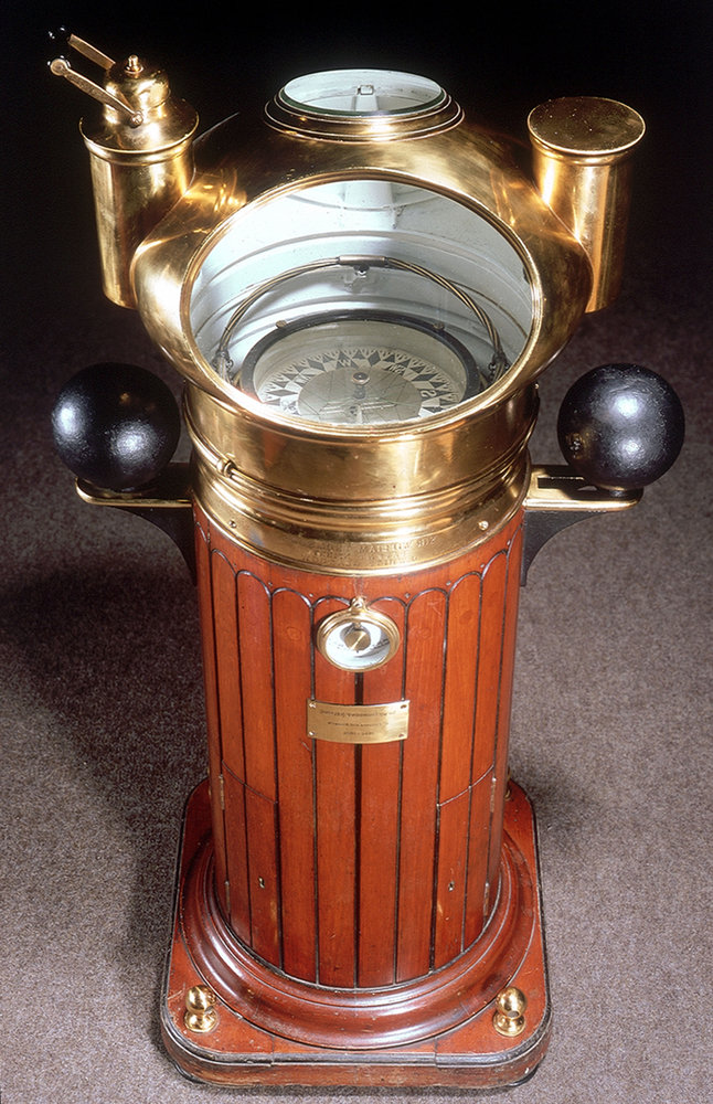
As it turned out, a carpenter (like I said, you can't make this stuff up) cum clockmaker by the name of John Harrison had pretty much already solved the Longitude problem with his grasshopper escapement, and with his unique double bar-bell pendulum and springs, which were insensitive to the rocking of the boat, and which kept unbelievably accurate time. uh ... for the time.
Anyway, all he had to do was perfect it (with things like temperature and moisture compensation) (it is going out to sea, after all), and miniaturize it (in metal), because he very rightly sensed that the solution was yet another mechanical device, like the already prevalent compass, that could be read in any weather, and at any time of day. So he traveled to London, took out a loan, and set to work. And, of course, he threw his hat in the ring, meaning that everyone knew that he was a contender for the prize. But the Board of Longitude, top-heavy with British Lords, nobles, and other snobbery, were determined to exclude this lowly clock-maker and, worse, mere carpenter (Have they EVER read their Bibles at all?!), from ever even competing for the prize.
Harrison ultimately labored for DECADES to perfect his marine chronometer, and to win the prize, making it practically unbeatable in the process. I mean, there was just nothing more that could be done. Well, mostly. Others would eventually catch up to him, and, later, even improve on his designs, but the truth is that he was the first by several very important years in history. And all future improvements were improvements, not on anyone else's designs, but on Harrison's design. Captain Cook even used one of Harrison's watches (the H2 or H5 I think it was) on his historic second journey, and was, using the watch, able to accurately map the coasts of Hawaii (before they later ate him), and wrote nothing but the highest praise for the device in his journal.
That was 1772. Three years till the Americas would start getting wildly out of hand. And Harrison still wasn't awarded the prize for some reason. Parliament and the (Royal) Board of Longitude were just determined that this commoner was not going to emerge the victor. So bad was the opposition, that Harrison's son eventually wrote directly to the new King, George III, who, in one of his saner moments, came down on Harrison's side and ordered Parliament to pay Harrison the prize money.
Parliament, of course, decided that George was just being crazy again, and ignored him. Completely.
Records get a bit fuzzy here. That's how bad the hostility was. Some say Harrison got the money, but not the prize. Others say he got the prize, but never all the money. Still others say that he got a collection of payments for various reasons that approximated the reward, and got the prize. But I can't even get my hands on all the documents to make my own decision. Whatever the case, the snobs in charge still would NOT use his watch. They were determined that only a solution provided by a noble would actually get used.
Agreed, the watches were expensive, costing about half as much as a ship itself, and that was a limiting factor, but England had about ONE THOUSAND ships at this time. The same sort of mass-production that made all those ships possible could also have made more watches available for less money. But, as I said, the snobs were determined that this wasn't going to happen. And it didn't. And, because it didn't, the British troops being sent to the Americas were effectively blind and hobbled, no better able to place men, materials, or guns up and down our coasts than they had been a hundred years earlier.
And the colonists were all on land. The British waged war from distant England, over thousands of miles of sea, without benefit of accurate navigation, against land-based rebels with good maps.
Now, recall what I was saying about surveying to get accurate measurements? Guess what another George, Washington, in this case, was busy doing in his youth? SURVEYING! He really knew the lay of the land. Like Columbus, he had the best maps. And, like anyone else with any sense, he wasn't sharing. The British had only their own shoddy maps, made without Harrison's watch.
And the rest, as they say, is history.
So, when did mighty Britain finally learn their lesson and start using Harrison's watches? Not by the time Harrison died. Not by the end of the Revolutionary War. Not even by the time the war of 1812 ended (in 1814). Britain wouldn't use that humble, brilliant man's invention, for which they had already paid, until FIFTY YEARS after he was dead and gone, not even until a decade after his son (who had become a major part of his father's campaign) had died, too.
That's the power of pride, the inability to admit, or even recognize, one's own fault, the single-minded obsession with 'saving face'. That's why a rich man will have a harder time getting into heaven than a camel will squeezing through the eye of a needle.
And Britain, mighty Britain, once vanquisher of the mighty Spanish Armada, was now left with only ...
... 200 ships.
I kid you not. You can look it all up.
Now, do you really think God had no part in all of this?
Remember that bit in Exodus about 'God' hardening Pharaoh's heart?
Like I said, for a nation so bent on liberating Christianity, you'd think they'd have done a better job of finding out just what it was they were liberating first.
The point is, this is a divine land!
I just don't see how anyone can deny the divine intervention plotting a course through an otherwise inscrutable tangle of disasters, human foibles, and coin-tosses. It's like when Christ walked right through the middle of a mob of attackers.
Remember that on Thanksgiving day.
Longitude (the movie ... starring Jeremy Irons)
The Clock That Changed the World (BBC History of the World)
The History of Navigation
Enjoy!